Christmas

•December 18, 2010 • 1 Comment

The origin of the Christmas tree is obscure.  According to Christian lore, the Christmas tree is associated with St Boniface and the German town of Geismar. Sometime in St Boniface’s lifetime (c. 672-754) he cut down the tree of Thor in order to disprove the legitimacy of the Norse gods to the local German tribe. St. Boniface saw a fir tree growing in the roots of the old oak.

The custom of erecting a Christmas Tree can be historically traced to 15th century Livonia (present-day Estonia and Latvia) and 16th century Northern Germany. According to the first documented uses of a Christmas tree in Estonia, in 1441, 1442, and 1514 the Brotherhood of the Blackheads erected a tree for the holidays in their brotherhood house in Reval (now Tallinn). At the last night of the celebrations leading up to the holidays, the tree was taken to the Town Hall Square where the members of the brotherhood danced around it.  In 1584, the pastor and chronicler Balthasar Russow wrote of an established tradition of setting up a decorated spruce at the market square where the young men “went with a flock of maidens and women, first sang and danced there and then set the tree aflame”. In that period, the guilds started erecting Christmas trees in front of their guildhalls: Ingeborg Weber-Kellermann(Marburg  professor of European ethology) found a Bremen guild chronicle of 1570 which reports how a small tree was decorated with “apples, nuts, dates, pretzels and paper flowers” and erected in the guild-house, for the benefit of the guild members’ children, who collected the dainties on Christmas Day.

18th and 19th Century

By the early 18th century, the custom had become common in towns of the upper Rhineland, but it had not yet spread to rural areas. Wax candles are attested from the late 18th century. The Christmas tree remained confined to the upper Rhineland for a relatively long time. It was regarded as a Protestant custom by the Roman Catholic majority along the lower Rhine and was spread there only by Prussian officials who were moved there in the wake of the Congress of Vienna in 1815. Just like Christmas (Germanic Yuletide), the Christmas tree was more or less accepted by the Roman Catholic Church because it could not prevent its use.

The tradition was introduced to Canada in the winter of 1781 by Brunswick soldiers stationed in the Province of Quebec to garrison the colony against American attack. General Friedrich Adolf Riedesel and his wife, the Baroness von Riedesel, held a Christmas party at Sorel, delighting their guests with a fir tree decorated with candles and fruits.

In the early 19th century, the custom became popular among the nobility and spread to royal courts as far as Russia. Princess Henrietta of Nassau-Weilburg introduced the Christmas tree to Vienna in 1816, and the custom spread across Austria in the following years. In France, the first Christmas tree was introduced in 1840 by the duchesse d’Orléans.

20th Century

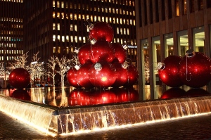
Many cities, towns, and department stores put up public Christmas trees outdoors, such as the Rich’s Great Tree in Atlanta, the Rockefeller Center Christmas Tree in New York City and the large Christmas tree at Victoria Square in Adelaide. During most of the 1970s and 1980s, the largest decorated Christmas tree in the world was put up every year on the property of The National Enquirer in Lantana, Florida. This tradition grew into one of the most spectacular and celebrated events in the history of southern Florida, but was discontinued on the death of the paper’s founder in the late 1980s.

In some cities, a Festival of Trees is organized around the decoration and display of multiple trees as charity events. In some cases the trees represent special commemorative gifts, such as in Trafalgar Square in London, where the City of Oslo, Norway presents a tree to the people of London as a token of appreciation for the British support of Norwegian resistance during the Second World War; in Boston, where the tree is a gift from the province of Nova Scotia, in thanks for rapid deployment of supplies and rescuers to the 1917 ammunition ship explosion that levelled the city of Halifax; and in Newcastle upon Tyne, where the 15 m-tall main civic Christmas tree is an annual gift from the city of Bergen, Norway, in thanks for the part played by soldiers from Newcastle in liberating Bergen from Nazi occupation. Norway also annually gifts a Christmas tree to Washington D.C. as a symbol of friendship between Norway and the US and as an expression of gratitude from Norway for the help received from the US during World War II.

The United States National Christmas Tree is lit each year on the South Lawn of the White House. Today, the lighting of the National Christmas Tree is part of what has become a major holiday event at the White House. President Jimmy Carter lit only the crowning star atop the Tree in 1979 in honour of the Americans being held hostage in Iran. The same was true in 1980, except the tree was fully lit for 417 seconds, one second for each day the hostages had been in captivity.

The term Charlie Brown Christmas tree is used in the United States and Canada to describe any poor-looking or malformed little tree. Some tree buyers intentionally adopt such trees, feeling sympathetic to their plights. The term comes from the appearance of Charlie Brown’s Christmas tree in the TV special A Charlie Brown Christmas.

Controversy

The Christmas tree has seen an amount of controversy, mainly involving separation of church and state, the secular and non-secular usage of the tree as well as groups who oppose usage of the tree on the grounds of interpretation of scripture and pagan origins or pagan character of the custom.

In 2005, the Seattle-Tacoma International Airport removed all of its Christmas trees in the middle of the night rather than allow a rabbi to put up a menorah near the largest tree display. Officials feared that one display would open the door for other religious displays, and, in 2006, they opted to display a grove of birches in polyethylene terephthalate snow rather than religious symbols or Christmas trees.

In 2005, the city of Boston renamed the spruce tree used to decorate the Boston Common a “Holiday Tree” rather than a “Christmas Tree”. The name change drew a poor response from the public and was changed back to “Christmas Tree” after being threatened with several lawsuits by Rev. Jerry Falwell and the Alliance Defense Fund. In the same year, Speaker of the House, Dennis Hastert, R-Ill., asked that the tree that decorates the Capitol grounds to be renamed back to “Christmas tree”. It had been renamed “Holiday tree” in the 1990s.

Text: Wiki
Photos: Houry Najjarian (Houry Photography)

Ellis Island, through my eyes

•June 21, 2010 • 4 Comments

Ellis Island (yesterday)

More than a hundred million americans can claim ancestors who came through Ellis Island.

The island had many different names – including Kioshk (Gull) Island, Oyster Island, Dyre’s Island and Bucking Island. And after a group of pirates were hung on the island, it became known as Gigget Island, before the Revolutionary war.  Then the island was acquired by Samuel Ellis, shortly prior the Revolutionary War,  a New York merchant who ran a small tavern on the island to cater to all the folks – primarily fishermen – who made their living on the waters in and around the island.  The heirs of Samuel Ellis sold the island to New York State, in 1808. New York State sold it to the federal government later that year. Through these transfers and up to the present, it has maintained the name Ellis Island.

There were probably as many reasons for coming to America,” wrote President John f. Kennedy in A Nation of Immigrants, ” as there were people  who came.

I remember, when I was 7 or 8, we had friends visiting and the main subject between my dad and his friends was always “USA” and “Canada”.  My dad always wanted to come to the States and his friends were dreaming of Canada.  They all had their dreams fulfilled.

Beginning 1892, the majority –some 12 million– too their first steps toward becoming Americans at Ellis Island.  Today Ellis island is memorial to all who have made this nation their adopted home.  He we can see where the Old World met the New.

Ellis Island (today)

Ellis Island, main entrance

Through America’s Gate

The exhibits in the wing describe step-by-step what most new arrivals experienced on Ellis island, the federal government’s first immigrant inspection depot.  Ellis Island’s main function was to screen out those considered undesirable – the incurably ill, the impoverished, the disabled, criminals, and all the others barred by the immigration laws of the United States.

For the vast majority of immigrants, Ellis island meant three to five hours of waiting for a brief medical and legal examination prior to admittance.  for others, it meant a longer stay with additional testing or a legal hearing.  For an unfortunate 2%, it meant exclusion and return trip to the homeland.

During Ellis Island’s busiest years, this wing contained legal hearing rooms, waiting rooms for witnesses, detention quarters, and staff offices.  The wing has been carefully restored to its appearance during the period 1918 to 1924.

The Hearing Room

This room has been restored to look as it did around 1911, during the period when it served as a Board of special Inquiry hearing room.

About 10% of all immigrants arriving at Ellis Island were held for a legal hearing.  Those thought “liable to become public charges”, or suspected of being contract laborers or worse, received yellow cards marked “S.I.”, which meant that their case would be decided by a Board of Special Inquiry.  Three boards were usually in session all day, and during busy seasons a fourth board was added.  Each board held 50 to 100 hearings daily in the presence of an interpreter and a stenographer.

Each board based its decision on the testimony of the immigrant and of friends or relatives allowed to speak on the immigrant’s behalf.  An immigrant who received an unfavorable decision from the board, could appeal directly to Washington D.C., with the help of a lawyer often provided by an immigrant aid society.  In almost 8 out of every 10 cases, these boards ruled to admit immigrants into the United States.  In total, only 2% of the over 12 million immigrants processed at Ellis island, were denied admission and sent back.

Medical Inspections

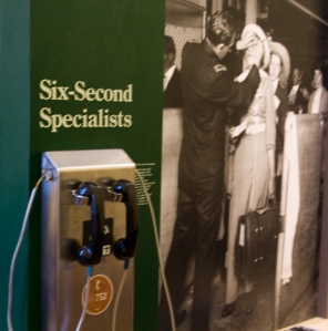
The United States Public Health Service operated an extensive medical service at the immigrant station, called U.S. Marine Hospital Number 43, more widely known as the Ellis Island Immigrant Hospital. It was the largest marine hospital in the nation. The station was staffed by uniformed military surgeons. They are best known for the role they played during the line inspection, in which they employed unusual techniques such as the use of the buttonhook to examine aliens for signs of eye diseases (particularly, trachoma) and the use of a chalk mark code. Symbols were chalked on the clothing of potentially sick immigrants following the six-second medical examination. The doctors would look at the immigrants as they climbed the stairs from the baggage area to the Great Hall. Immigrants’ behavior would be studied for difficulties in getting up the staircase. Some immigrants entered the country only by surreptitiously wiping the chalk marks off, or by turning their clothes inside out.

Dormitory Room

Ellis Island’s numerous dormitories were filled to capacity nearly every night with immigrants who were being temporarily detained. Many immigrants stayed in large dormitory rooms located here, along these balconies.

Great Hall, Third Floor Balcony

From 1900 to 1908, the dormitories consisted of two long, narrow rooms, one on either side of the balcony.  Each room accommodated about 300 detainees, who slept in triple-tiered bunk beds that could be raised, thus converting the dormitory into a daytime waiting area.  At night, immigrants received blankets to spread over their canvas or wire-mesh “mattresses.”

This room has been restored to its appearance in 1908, when the two balcony dormitories were refurbished and subdivided into 14 rooms.

The next round or major alterations took place in 1924, when the much-criticized bunks were replaced with single beds and real mattresses.  Though large dormitories were still maintained for single men and women, private rooms were now available for detained families.

Registry Room Views (beginning)

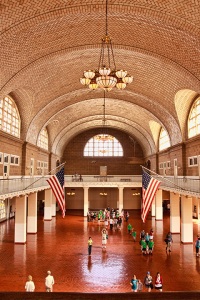
Perhaps no other place in America conjures up as strong an image of the immigration experience as does this hall.  The Registry Room on Ellis Island marked a great divide in the lives of millions of immigrants who had completed one long journey and were about to undertake another. This was their first stop in America.

While the enormous arched windows evoked the spirit of America’s 19th Century railroad stations – the principal gateways of our cities – the Registry Room’s floor plan accommodated the practical business of inspecting and sending immigrant travelers on their various ways.  Ellis Island officials periodically rearranged the floor plan to guide the flow of humanity more efficiently or, in later  years, to serve other purposes.  Iron piped alleys and wire cages gradually gave way to wooden benches and open spaces.

Here are few photographs taken from this end of the balcony, showing how the Registry Room changed over the years.

:

How the Great Hall looks today

I sat here for few minutes, closed my eyes, it was an eerie feeling.  I didn’t have any ancestors coming in through this Gate.  My husband did.  My mother-in-law’s uncle, a very young man than, waiting to board one of the ships, was approached by couple mid age ladies with a 14 years old young lady.  They introduced themselves as working in an orphanage and wanting to send this 14 years old to the States to her relatives and since he looked an honest person could he be kind enough to just have an eye on her while traveling? Aram, that was his name, realized Alice, her name, was really shy and looked like a lost puppy, promised to take care of her.  They became almost inseparable.  Aram realized that Alice wasn’t sure where she was going.  Who were her relatives.  What she would be doing in the States. By the time they were in Ellis Island they were engaged to be married.  They had three children, grand children and great grand children.  Uncle Aram died just a month before I got married with my husband, but I had the honor to meet Auntie Alice, a true Lady, devoted to her family and Armenian Church till her last day.  Sitting there on the bench these were my thoughts.
Sitting here, looking around me I was admiring the beautiful Guastavino tile ceiling, quarry tile floor, decorative Caen-stone plaster, and chandeliers installed in 1917, one year after a munitions explosion (set by German agents), on the nearby Black Tom Wharf in New Jersey, damaged much of the main building.

Some interesting sculptures at the main entrance:

Passengers and Ship Manifests:

Passenger Manifest

Alien List,  ship’s Manifest

Ship’s Manifest

Text, some internet and pamphlets

Photo: Houry Najjarian (Houry Photography)

Chiva Express

•March 14, 2010 • 4 Comments

My adventure with the “Chiva Express” started at the Station of Chimbacalle in Southern Quito, which has been recently restored to its old glory, to commemorate the centenary of the arrival of the first steam train of the Guayaquil & Quito Railway Co. to Quito in 1908, an event that joined Ecuador’s main cities (Guayaquil and Quito) and became the backbone that would forever change the politics, economy and the lives of the Ecuadorians.  On June 25, 2005 Metropolitan Touring started the operation of its highlight rail tours along the Ecuadorian Andes and down to the Coast, with new one-car vehicles on tracks, called the “Chiva Express”.

The Chiva has long been a favorite means of transportation in Ecuador, a colorful bus with plenty of room on the roof for people, bananas and perhaps chickens.  The first leg of the Chiva Express ride goes from Quito to the Tambillo Station, where we were transfered to a bus for a short ride to a dairy hacienda with cows, horses and llamas, where the most delicious local snack, more like a full meal, was served.  Then continued along the Pan American Highway up and down the slopes of Cotopaxi Volcano and into the fertile Valley of Latacunga for a visit to a rose plantation and a taste of the products of the land.  Continued by bus to Riobamba, and at the foot of imposing Chimborazo Volcano, we visited a Tagua workshop and warmed up with canelazo by the fireplace.

The fun of riding the “Chiva” has been combined with the historic Trans-Andean rail ride, down the famous Devil’s Nose from Quito in the Andean Highlands all the way down to Guayaquil on the coast. I enjoyed an exhilarating experience of riding on the back balcony of the car.

The two-day Quito/Riobamba/Guayaquil “Chiva Express” program was one of greatest thrilling highlights of my trip to Ecuador!! Even though my fear of heights is great, I am happy that didn’t overpower my sense of adventure, specially, one of the highlights of the “Chiva Express” is the the Devil’s Nose ride and back to .

Devil’s Nose

Several plans and attempts were made to build the railway from Guayaquil to Quito, since 1860 until 1874, when the first locomotive reached Milagro.  In 1895, Eloy Alfaro, then President of Ecuador, made contact with the North American technicians Archer Harman and Edward Morely, representatives of an American Company interested in the building of the “most difficult railway in the world” as it was called at that time, “The Guayaquil & Quito Railway Company” which would link the main port of Ecuador, Guayaquil on the Pacific Coast to the capital city of Quito, high up in the Andes.  An agreement was reached, and the construction started in 1899.

The tracks finally reached a huge obstacle -an almost perpendicular wall of rock- called the “Devil’s Nose”.  Many lives were shed in the building of what until now is considered a masterpiece of railway engineering: a zigazag carved out of the rock, which allows the train, by advancing and backing up, to reach the necessary height to the town of Alausí.  The train finally reached Alausí by September 1902 and Riobamba and Quito by July 1905.

From this point on, the construction was easier. The highest point of the route – Urbina 3604 meters – was reached by the end of 1905 and finally on June 25, 1908 the train made its triumphal entrance to Quito and was received by arches of palms, laurel and flowers, bells tolling banquets, dances and popular festivities that lasted four days.

Unless you took this ride to the Devil’s Nose it is hard to explain the exhilaration mixed with fear. The constantly changing scenery was awesome: snow-capped peaks, high treeless plateau, rushing streams, lush valleys, and steep slopes with patchworks of terraced fields and small Indian villages.

The rail trip took us on the “Chiva Express” from Riobamba to Alausí and on to the famous 1,000-foot Devil’s Nose (La Nariz del Diablo) switchback, an almost sheer cliff on which the railway track zigzags down a ledge cut into the mountainside overhanging a river gorge south of Alausí. On one side, the Rock on the other, inches away from the ravine!!

I was on the back balcony the hole ride camera in hand shooting and praying the images captured were clear.  When suddenly the one car train came to a halt. To my question if anything was wrong? the answer was: “No, we will be  going back down, as soon as the track pins are set properly cause you see, going back down is by putting the gear on reverse, just like driving a car in reverse gear”.

Going down, around the mountain, ON  REVERSE???!!!! Me, a grown woman, mother of two, sometimes having title of superwoman, suddenly found myself on the floor of the back balcony looking for my heart. As if that was not enough, I started hearing church bells!! I thought, if  this is the end for me, I better record what I am seeing and picking up my camera started shooting the fantastic scenery first from between the wide bars of the balcony wall, and little by little standing up and snapping that shutter not caring, exposure, composition or anything!!! The descent could have been 20 minutes or more and we were at the bottom of the mountain on the bank of the river.  We were speechless at the wild beauty surrounding us!!

The adventure continued from Chiva Express down the slopes of the Andes while we experienced the transition from Andean ecosystems to the lush tropical coastal vegetation: bananas, oranges, pineapples, ginger and wooden farm houses on stilts. The last leg of the “Chiva Express” ended in Bucay, and on by motorcar to Guayaquil.

(Some excerpts from internet and some from brochures).

(photos by: Houry Photography)

***************

************

*****

*

Volcanic formation of The Galapagos Archipelago!!!

•February 19, 2010 • 1 Comment

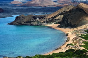
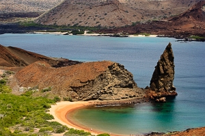
Bartolome Island, Sullivan Bay, Santiago Island

The following informations are from various internet pages!!

Galapagos Islands Volcanic Formation – The islands of the Galápagos archipelago are formed by volcanic processes and continue to form with frequent eruptions.  For example, Fernandina Island has had 14 eruptions in the last 37 years.

The hot spot is the origin of basalt lava which is born in the depths of the earth’s mangle where it ascends forming magma (melted rock) that reaches the surface of the planet giving rise to volcanoes.

According to the theory of tectonic plates, in the depths of the seas there is part of the surface of land that is not stable and it moves forming deposits of melted rock upon which the solid surface of the mantle forms a solid layer.(Photo: Pinnacle Rock)

A constant friction process exists between the rigid zone and the soft one which breaks the extrernal layer of the earth which forms tectonic plates.

The plate on which the Galápagos Islands are found is called the Nazca Plate and moves in the westerly-easterly direction.

Apparently the hot spots do not move in relation to the planet but the plates do.  Thus, it is possible to build up chains of volcanic material under the water and occasionally islands such as the peaks of chains.

This is how the Galápagos Islands originated.  The rocks that form the western party of Galápagos are very young (less than one million years old) but the chain extends from Galápagos to the edge of the Continent of South America (Carniege Chain).  It is 22 million years old.  These chains affect the movement of the underwater currents and the settling of sediments.

Bartolome Island, Twin Bay, Pinnacle Rock

As land masses go, the Galápagos Islands are not very old. A little over four million years ago there was open ocean where they now lie, on the equator some 600 miles west of Ecuador. But submarine volcanic activity slowly built up the string of islands that Darwin visited in 1835. Indeed, it was Darwin who first recognized their volcanic origin, and who understood the profound implications of this origin for the history of life. For if the islands were volcanic, they must have formed after the creation of the world, and the organisms living there must have migrated there from someplace else. But since those organisms are found nowhere else, Darwin finally had to conclude that they had evolved there from South American ancestors.

After Darwin’s visit, and well into this century, the origin of the islands have been disputed. Many thought that they had once been part of the mainland, or connected to it by a land bridge. Eventually, however, Darwin was vindicated; these islands had a volcanic origin separate from the mainland and were never connected to it.

Plate Tectonics and the Formation of the Galapagos Islands

(Photo: Aerial view of islands)

But Darwin only had part of the answer. A more complete answer to the origin of the Galápagos could not be had until after 1958, when continental drift, or plate tectonics, were discovered. We now understand that the surface of the earth is divided into massive tectonic plates which slowly drift across the globe. The formation of the Galápagos is intimately tied to the history of the Nazca plate, on which they lie.

The Galápagos are located on the very northern edge of the Nazca plate, which is bounded by the Cocos (north), the Pacific (west), the South American (east), and the Antarctic (south)

plates (see map). The Nazca plate itself is currently drifting south, away from the Cocos plate, and east, away from the Pacific plate. Since the net direction of drift is southeast, the Nazca plate is colliding with the South American plate. At the point of collision, the South American plate, which is made of light continental crust, is riding up over the Nazca plate, which is made of dense oceanic crust. This type of plate interaction is called subduction.

As the Nazca plate is forced into the mantle, it melts and its melt products work their way up to the surface to form volcanoes. The land is further raised by the crumpling effect as the western edge of the continent rides up over the descending plate. The result of all of this is the Andes, a young, highly volcanic, rapidly growing mountain chain. This same movement of the Nazca plate is responsible for producing the cluster of volcanic islands we call Galápagos.

There is a large body of geophysical evidence for the existence of enormous plumes of hot mantle material that originate near the earth’s core and rise all the way to the crust. These plumes seem to be stable over many millions of years. and with time, they burn through the crust to form an underwater volcano which may eventually grow big enough to become an island.. But, because the crustal plate is in constant motion, the island will eventually move off of the hot spot. thereby making room for a second volcanic island. And a third, and a fourth…. Thus are archipelagos like the Galápagos formed.

Islands farthest from the hot spot are older and more eroded while islands near or on the hot spot are younger and steeper. Thus Isla San Cristóbal, the nearest to the mainland, is approximately four million years old and composed of eroded, rounded cones, while Isla Fernandina dates at less than 7000 years and is considered to be one of the most active volcanoes in the world. Recently former Galápagos islands, now submerged, have been discovered between Isla San Cristóbal and the mainland. This discovery may double the age of the islands. Indeed, several million years from now the present islands may likewise sink beneath the waves only to be replaced by a new set of Galápagos Islands. Who can imagine what course further evolution will take!?

Galapagos Volcanoes

Mid-ocean islands like the Galapagos are formed from basalt, the most basic of all types of lava. Basalt has a very different chemical composition from the lavas that erupt from continental volcanoes, and is much more fluid. Consequently, as the lava flows build up to produce a volcanic cone, the island cones have a much shallower slope than those on the mainland. These shallow-sloped volcanoes are called shield volcanoes and in the Galapagos, they are often compared to over-turned soup bowls. Such shield volcanoes can clearly be seen in the younger western islands of Isabela and Fernandina. To the east, the volcanoes are lower and more eroded.

Many volcanoes are topped by a caldera, a large circular depression derived from the original crater (sometimes this is subsequently filled in by new lava). During an eruption, the crater is fed from a magma chamber, but as activity dies down, the magma withdraws, leaving a large, open cavity. The ceiling periodically collapses, lowering the crater floor and widening the diameter. There was a major caldera collapse on Fernandina in June, 1968, when the floor dropped 300 meters! The largest caldera in the islands is that of Volcan Sierra Negra, Isabela, which is 7 by 10 km.

Lava Caves and Pit Craters

Cave on Santa Cruz Island

Two other volcanic features commonly seen by visitors are lava tunnels and pit craters. As lava flows downslope, the top often cools and forms an insulating crust that keeps the interior lava hot and running. As the eruption subsides, the molten lava drains out of the end, living a hollow chamber that can be many kilometers in length. These tubes have smooth sides with grooves that show different levels of lava. Such lava tubes can be seen in the highlands of Santa Cruz, and there is one just outside of Puerto Ayora. Pit craters are giant sink-holes that were never eruptive. These formed when subterranean magma chambers were emptied and the roofs collapsed. Classic pit craters are found at Los Gemelos in the Santa Cruz highlands.

The Galapagos Islands are considered to be one of the most volcanic regions in the world, and in recent years there have been small eruptions at Fernandina and Marchena. In 1979 there was a major, eruption of Volcan Cerro Azul. Benjamin Morrell, captain of theTartar, described a spectacular eruption of Fernandina in 1825.

Pit Craters, called father and son(one deeper and larger)

(Photos by: Houry Photography)

***********************

***************

*****

*


Iglesia de la Compania de Jesus, Quito

•February 13, 2010 • 2 Comments

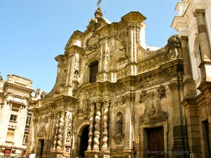
La Compañia, façade

Quito is a historical center, developed in the valley of the high mountains of the Andes. It is about 40 km (24.85 miles) long and 5 km (3.1 miles) at its widest.  With its Spanish colonial architecture Quito is a jewel.  It’s a city with amazing churches, palaces and a history rich of past civilization.

One church that stands out, is Iglesia de La Compañia de Jesus.  Not so much impressive as its size but for its great design, for the beautiful mind of the architects and awe-inspiring lavishness.

La Compañia, short for Iglesia de la Compañia de Jesus, is the heart for the new “Viceprovincia de Nuevo Reino y Quito” with its construction that started in the year 1605.

(from Wiki): Styled in Latin American Baroque, it took Jesuit priests 160 years to finish construction. Design elements include a near symmetrical façade, Moorish influence in the nave, and artwork by artists of the Quito School of Art. The bell tower was the tallest structure in colonial Quito, but was toppled by two earthquakes in 1859 & 1868. In the past twenty-years, the church has gone under heavy restoration, especially after a fire damaged the interior nave.

The remains of Ecuador’s patron saint, Mariana de Jesus, are in a sarcophagus that is part of the main altar.”

(from Frommers):  “This Jesuit church is one of the great baroque masterpieces in South America. All the work took 160 years to complete (1605-1765). The facade won’t fail to impress you — the carvings are unbelievably detailed. Notice the Solomonic columns, which are symbolic of the Catholic doctrine that life’s journey starts at the bottom (on earth), but by following the holy path, it ends at heaven.

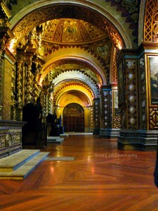
Almost every inch of the interior has intricate decorations. When you enter La Compañía, look for the symbols of the sun in both the main door to the church and the ceiling. The sun was a very important Inca symbol, and the Spanish thought that if they decorated the entryway with indigenous symbols, it might encourage local people to join the church. The walls and ceilings of La Compañía are typical of Moorish design — you will only see geometric shapes but no human forms. The building has been under renovation for the past several years, and some of the gold leaf on the ceiling and walls has been restored to its original luster. Natural sunlight and candlelight really bring out an angelic brilliance.”

The interior is said to have taken seven tons of gold.

(Photos by: Houry Photography)

The Sunday’s Funnies

***********************

***************

*****

*

San Francisco de Quito

•February 6, 2010 • 4 Comments

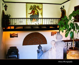
Ground Floor Court

What a thrill it was to organize a trip to Ecuador!! The Center of the World!! Did my research, prepared a list of most important things.  I wanted to see everything, at least as much as I could.  While doing my research through internet, books and friends, I found out a very important fact.  The elevation of the city’s central square, Plaza de la Independencia or Plaza Grande, is about 9,186 ft, or 2,800m. This means first couple days in Quito you have to take it easy, eat light, and walk slow, not too much activity.

Through a friend I found out there is a prescription medicine for that!!! Definitely that was my solution; my intention was to rest only at night, after seeing every inch of the city and most importantly photographing every inch square!! Slowing down, not in my book!!

From my readings I found out a day and a night in Quito, (beginning of the package tour), was not enough!! After all, Quito is a UNESCO heritage city!! I decided to go few days ahead, thankfully my friend and my roommate agreed to the same. We were 12 people going.  I talked with the remaining 10 about this idea and one more couple liked it and agreed to do the same.

We could have stayed at the same hotel that the Agency had booked us in the “package” but it was not adventurous enough for me.  I wanted something different, more of the taste of the city, more of history than just a franchise.

The first name of a hotel that stuck in my mind was San Francisco de Quito!! I read over and over about its history on their site. With each reading, I was more convinced that San Francisco de Quito was the place I wanted to spend on my semi solo adventure!! Lots of pros about this choice and plus one, the price: $42.00/night!!! The cons: the location!! NOT recommended, being situated “en el Centro”, crime area after dusk!!! But, I didn’t mind the cons, I was adamant!!! And most important there was a way to avoid being a target by taking a cab even for short distances instead of walking!!!

Called my friend and roommate to be and informed her about my finding and desire. First she was worried but couple days later she was as enthusiastic about it as I was and her only worry was my photography gears!! For a second a black cloud tried to wipe my spirits but I dismissed quickly.

And Hotel San Francisco de Quito was booked!!!

Here is what their site said:

  • San Francisco de Quito city was founded in 1534.  It is in this year that the land was distributed to the Spanish conquerors and founders according to their hierarchy.  The Spanish Miguel Lozada received the land where today hotel San Francisco de Quito is located.  He built a house which was destroyed by an earthquake in 1698, one of the earthquakes that destroyed most of Real Audiencia de Quito territory.
  • In 1698, the Spanish Juan de Dios Padilla built a new house with two levels.  The first level had the main patio for milking and watering cows. A stable for horses was built in the  as well as a little chapel.  The second level had bedrooms, a dining room and a kitchen.
  • The House presents colonial and Quiteño architecture characteristics of the XVII century, with more than one meter wide walls made of adobe, (mix of mud and straw).
  • In 1747, its owner, who belonged to a religious group painted the “Virgen de Rosario” fresco on the wall over the stone stairs that lead to the second level.   1989At the last reconstruction of the house, in 1989, this fresco was found behind another wall that was covering it.
  • The last reconstruction of this house, cultural heritage of the city was finished in 1997, year of Hotel San Francisco de Quito foundation, it keeps all its original details.
  • Hotel San Francisco de Quito is located just in the heart of the Historical old Town, few steps from the beautiful plazas, churches, convents, museums and touristic places, it is surrounded by all the cultural and historical value of the old city.

Little history from Wiki:

Born Sebastián Moyano in the province of Córdoba, Spain, in either 1479 or 1480. He took the name Belalcázar or Benalcázar as that was the name of the castle-town near to his birthplace in Córdoba. According to various sources, he may have left for the New World with Christopher Columbus as early as 1498, but Juan de Castellanos wrote that he killed a mule in 1507, and fled Spain for the West Indies due to fear of punishment, and as a chance to escape the poverty in which he lived.

Benalcázar, Pizarro’s lieutenant and fellow Extremaduran, had already departed from San Miguel with 140 foot soldiers and a few horses on his conquering mission to Ecuador. At the foot of Mount Chimborazo, near the modern city of Riobamba (Ecuador) he met and defeated the forces of the great Inca warrior Rumiñahui with the aid of Cañari tribesmen who served as guides and allies to the conquering Spaniards. Rumiñahui fell back to Quito, and, while in pursuit of the Inca army, Benalcázar encountered another, quite sizable, conquering party led by Guatemalan Governor Pedro de Alvarado. Bored with administering Central America, Alvarado had set sail for the south without the crown’s authorization, landed on the Ecuadorian coast, and marched inland to the Sierra. Most of Alvarado’s men joined Benalcázar for the siege of Quito. In 1533, Rumiñahui, burned the city to prevent the Spanish from taking it, thereby destroying any traces of the ancient pre-Hispanic city.

In 1534 Sebastián de Belalcázar along with Diego de Almagro established the city of San Francisco de Quito on top of the ruins of the secondary Inca capital naming it in honor of Pizzaro. It was not until December 1540 that Quito received its first captain-general in the person of Francisco Pizzaro’s brother, Gonzalo Pizarro.

Declared by UNESCO Cultural Patrimony of the Humanity in 1978, Quito (2800 m.a.s.l.), is a large city loaded of history. The chronicler say, that before the Spanish foundation in 1534, the general of the Atahualpa Inca, Ruminahui (face of stone), set fire to the palaces and buildings constructed by the “sons of the Sun”.

***********************

***************

*****

*

(Photos by: Houry Photography)

Chilpancingo!!

•February 1, 2010 • 3 Comments

(Waxflower)

Today, at lunch time, as my usual, left the office with my camera for a walk.  I knew well that I wouldn’t be able to get many shot since I had forgotten to recharge the battery.  It was sunny but bitter cold and the wind was not helping, I tried to walk on the sunny side of the sidewalks but tall skyscrapers were blocking the sun.

After walking few blocks, I decided to return to the office, but instead of turning back on my steps,  made a left turn on a street thinking few more than I’ll make another left towards my office bldg.

Manhattan, NY, has the most amazing corner stores where fresh-cut flowers bouquets make their home alongside of the stores on the sidewalk with one attendant.  Most of these attendants are Central/South American and very pleasant.

In winter, they have their portable transparent tent/wall with a door to shield themselves and those beautiful flowers and plants, from cold, wind, rain and snow.

At this particular corner that I was ready to turn left, there was this store with its floral stand and its tent/wall shield.  First, I hesitated, than I walked in and sure enough the attendant was a Central American young man.  I had  question about some flower’s name.  He was curious about my camera.  He surprised me with his good English.  His name, Jenaro from Mexico.  No, not from Mexico City, but from Chilpancingo, not to far from Acapulco.

Chilpancingo? This time I had a paper and pen on me and I wrote the city’s name down, his name and few of the flower’s names. He was very pleasant and has been in the state for only a month and had studied English in Chilpancingo!! He didn’t mind me taking some shots. Few minutes later, it was time for me to go back to work, good thing since my battery died too.

Chilpancingo!! First time I hear a city by that name!!! Laptop on, google on, search engine fired up.  Here is what Wikipedia says:

Chilpancingo (formally Chilpancingo de los Bravo), also known as Ciudad Bravo, is the capital, and second-largest city of the state of Guerrero, Mexico. It is located at 17°33′0″N 99°30′0″W / 17.55°N 99.5°W / 17.55; -99.5. In the 2005 census the population of the city of Chilpancingo was 166,796. Its surrounding municipality, of which it is municipal seat, had a population of 214,219 persons. The municipality has an area of 2,338.4 km² (902.86 sq miles) located in the south-central part of the state.

The city is located on Federal Highway 95 which connects Acapulco to Mexico City

Chilpancingo is where the National Congress met in 1813 to discuss Mexico’s future as an independent nation.

On April 27, 2009 an earthquake with a magnitude of 5.6 was centered near Chilpancingo.”

from the Encyclopædia Britannica

Chilpancingo lies in the Sierra Madre del Sur along the Huacapa River, which descends through the inland flanks of the mountains. In pre-Columbian times, the Olmec left remarkable cave paintings in the nearby Juxtlahuaca caverns, which include an extensive tunnel network and a subterranean lake. Spanish conquistadores founded Chilpancingo (“Place of Wasps”) in 1591. It was the site of the first Mexican congress, convoked in 1813 by José María Morelos y Pavón. The prefix de los Bravo (“of the Bravo [family]”) was added to its name in honour of its native sons.”

(photos by: Houry Photography)

***********************

***************

*****

*

And now, the Sunday’s Funnies!!!

•January 31, 2010 • 2 Comments

Sooo Funny

Ariston Floral Boutique

•January 27, 2010 • 3 Comments

(Houry Photography)

Like yesterday, today I didn’t feel like much photographing!! Something real unusual for me, usually I can’t wait to get out camera in hand and take a snap.

While in the elevator, I remembered that one time I had walked in a nice floral boutique and the gentleman had let me take some shots of the beautiful flowers!! But how much of the same can I photograph?  and where was that boutique? I guess I was hoping for rejection and felt better that it wasn’t really my disposition of taking picture but the florist fault, smiled to myself on this crazy thought and went for looking the specific boutique.

Found it!!! Meet Alexandros, ha!!

He walks towards me and says with a smile: “How can I help you?”.  I said: ” Do you think I can take some shots of your beautiful flowers? I promise I won’t take any shots of the arrangements!!”  He asked me where I was from, I said I am Armenian, I guess my accent gave me away, hahaha, I found out he was Greek!! He said go ahead, sure, but just flowers no arrangements, please!!

While taking my shots, we chatted me shooting, he working!! He was very skilled and designing gorgeous arrangements with tulips, orchids, hydrangeas, luscious green leaves, gorgeous roses, the most beautiful Gerbera daisies and Cala Lilies!!!

Alexandros was born in Greece and from young age came to the US. Went to high school and didn’t want to pride by asking if he went to college or not.  He started this business 40 years ago.  Got married and has three children and he turned his business into family business.  This particular boutique, in Midtown Manhattan, is  his second location that he started three years ago; the first one is/was located in Downtown Manhattan.

His nephew, Theo, is working with him too.  In this store, three more employees and all working together in harmony.  You could sense that Alexandros is a good man, another gentleman was there too and I guess Alexandros younger brother.

Mostly the Ariston Floral Boutique does business with corporate accounts, hotels, banquets and weddings. They don’t mind walk-ins.

They helped me out with the name of some plants and branches full of buds and and few blooms.

(Houry Photography: Quince blooms)

I thanked them for their time, help, kindness and hospitality!! Tomorrow, I’ll surprise them with some coffee and donuts. They deserve that, don’t you think!!

Here is the site link if interested: Ariston Floral Boutique

(Photographs: Houry Photography)

Help to Haiti

•January 15, 2010 • Leave a Comment

The disaster of Haiti’s earthquake news shook the world. At least I got good news about a colleague of mine who was visiting his country, Haiti, with his wife and two children when the disaster happened. Today, we got the news that they are safe and sound!!!

How many people can give receive good news!!!

Help is needed. Please, make your donations through a trustworthy organization such as UNICEF and Red Cross, text HAITI to 90999 on your cell or call directly 1-800-RED-CROSS . Each one of us should take upon ourselves to give a helping hand.

Heartbreaking stories and scenes.  My prayers to the lost souls and to the survivors.

Or

100 Years - Armenian Relief Society of Western USA

ARS Issues Appeal to Help Earthquake Victims in Haiti
The Armenian Relief Society of Western U.S.A. (ARS), Regional Executive board issued an appeal to mobilize its members and the community at large to contribute to the ARS Haiti Relief Fund and lend a hand to ongoing disaster relief efforts.
“The ARS feels the suffering of the Haitian people, especially since we experienced similar devastation after the 1988 earthquake in Armenia,” said Sossie Poladian, Chairperson of the ARS Regional Executive. She added, “Many of us, still remember the pain and anguish that we felt and how comforting it was to know that the world came to help the people of Armenia. It is our duty to help the Haitians who fell victim to a similar disaster.”
Since the ARS was founded a century ago, disaster relief has been one of its humanitarian missions. Earthquakes, tsunamis and hurricanes from Greece to Mexico to our own backyard in Louisiana have flung the ARS into relief efforts.
Our community is urged to be generous with donations, knowing that every donation small or large can make a difference in the lives of those who are suffering in their devastated nation.
Tax-deductible donations can be securely made on-line at www.arswestusa.org/donate or checks  payable to the “ARS of Western USA” can be mailed to ARS of Western USA, Regional Executive at 517 W. Glenoaks Blvd., Glendale, CA 91202-2812. The web donations default to “Haiti Relief Fund” and the checks need to indicate the same on the memo field.